
Loading...
Loading...
As I’ve said elsewhere, my main interest in spacecraft lies with those
that have left the vicinity of the Earth, to the Moon, the Planets and beyond.
But here are a few probes that don’t satisfy that criterion, but are nevertheless interesting.
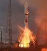
NASA launched four identical spacecraft on 12th March 2015 on a billion-dollar mission to study the explosive give-and-take between the magnetic fields of our planet and the sun. The uncrewed Atlas 5 rocket – and NASA’s Magnetospheric Multiscale spacecraft – soared into a clear late-night sky from Cape Canaveral Air Force Station in Florida right on time.
The quartet of MMS observatories were placed into an oblong orbit stretching tens of thousands of miles into the magnetosphere – nearly halfway to the moon at one point. They fly in pyramid formation, between 6 miles and 250 miles apart, to provide 3-D views of magnetic reconnection on the smallest of scales.
Ariel was a British satellite research programme conducted between the early 1960s and 1980s. Six satellites were launched as part of the programme, starting with the first British satellite, Ariel 1, which was launched on 26th April 1962, and concluding with the launch of Ariel 6 on 2nd June 1979. The first four were devoted to studying the ionosphere, the remaining two to X-ray astronomy and cosmic-ray studies.
The programme was conducted by the Science Research Council. The first two spacecraft were constructed by the United States National Aeronautics and Space Administration (NASA), with subsequent spacecraft being produced in Britain. All launches were conducted using American rockets; Ariel 1 on a Thor-Delta, and the remainder on Scouts.
In late 1959, the Science and Engineering Research Council (SERC) proposed the development of Ariel 1 to NASA, following an offer made by the United States at a meeting of the Committee on Space Research (COSPAR, established by the International Council for Science in 1958) to provide assistance to other countries with the development and launch of scientific spacecraft. By early the following year the two countries had decided upon terms for the programme’s scope and which organisations would be responsible for which parts of the programme.
Ariel 1 (1962 Omicron 1, later reclassified 1962-015A), also known as UK-1 and S-55, was the first British satellite. Its launch on 26th April 1962 made the United Kingdom the third country to operate a satellite, after the Soviet Union and the USA. It was constructed in the United States by NASA, under an agreement reached as the result of political discussions in 1959 and 1960.
NASA constructed and launched the satellite, while SERC provided the experiments, conducted operations, and later analysed and interpreted the results. Construction of the satellite was at the Goddard Space Flight Center. Ariel 1, with a mass of 62 kilograms (140 pounds), was launched aboard an American Thor–Delta rocket from Launch Complex 17A at the Cape Canaveral Air Force Station, at 18:00:16 GMT on 26th April 1962. It decayed from orbit on 24th April 1976.
Six experiments were carried aboard the satellite. Five of these examined the relationship between two types of solar radiation and changes in the Earth’s ionosphere. They took advantage of techniques developed in the Skylark programme. (Skylark was a British sounding rocket design, first launched in 1957 from Woomera, Australia and its 441st and final launch took place from Esrange, Sweden on 2nd May 2005.)
Ariel-1 was in a low earth orbit; its initial apoapsis was 1,202 kilometres (747 miles) and its periapsis was 397 kilometres (247 miles), with an orbital period of 100.9 minutes. It decayed from orbit on 24 April 1976.
Ariel 1 was seriously damaged by the Starfish Prime nuclear test.
Starfish Prime was a high-altitude nuclear test conducted by the United States on 9th July 1962 at 09:00:09 UTC. Launched by a Thor rocket and carrying a W49 thermonuclear warhead and a Mk. 2 reentry vehicle, the explosion took place 400 km above a point 31 km southwest of Johnston Island in the Pacific Ocean. It was one of five tests conducted by the USA in outer space and produced a yield equivalent to 1.4 megatons of TNT. The Thor missile reached a maximum height of about 1100 km, and the warhead detonated on its downward trajectory when it had fallen to the programmed altitude of 400 km. The nuclear warhead detonated 13 minutes and 41 seconds after liftoff of the Thor missile from Johnston Island.
Starfish Prime caused an electromagnetic pulse which was far larger than expected, so much larger that it drove much of the instrumentation off scale, causing great difficulty in getting accurate measurements. The pulse also made those effects known to the public by causing electrical damage in Hawaii, about 1,445 km away from the detonation point, knocking out about 300 streetlights, setting off numerous burglar alarms and damaging a telephone company microwave link. The damage to the microwave link shut down telephone calls from Kauai to the other Hawaiian islands.
After the Starfish Prime detonation, bright auroras were observed in the detonation area as well as in the southern conjugate region on the other side of the equator from the detonation. Strong electromagnetic signals were observed from the burst, as were significant magnetic field disturbances and earth currents.
While some of the energetic beta particles generated followed the Earth’s magnetic field and illuminated the sky, other high-energy (MeV) electrons became trapped and formed radiation belts around the earth, with some Starfish electrons remaining for five years. There was much uncertainty and debate about the composition, magnitude and potential adverse effects from this trapped radiation after the detonation. The U.S. Military became quite worried when three satellites in low earth orbit were disabled; these man-made radiation belts eventually crippled one-third of all satellites in low earth orbit. Seven satellites failed over the months following the test as radiation damaged their solar arrays or electronics, including the first commercial relay communication satellite, Telstar, TRAAC, Injun, and Ariel 1.
Ariel 2 (1964-015A), also known as UK-C, was a British radio astronomy satellite and was operated by the SERC. It was built in America by Westinghouse Electric, and had a mass at launch of 68 kilograms (150 pounds). It was the first satellite to be used for radio astronomy.
The launch of Ariel 2 was conducted by NASA, using a Scout X-3 rocket, at 17:25:23 GMT on 27th March 1964, from Launch Area 3 at the Wallops Island Flight Facility. Ariel 2 was placed into a low Earth orbit, with a perigee of 289 kilometres (180 miles), an apogee of 1,343 kilometres (835 miles), 51.6° inclination and an orbital period of 101.2 minutes. It ceased operations in November 1964, and subsequently decayed from orbit on 18th November 1967.
Ariel 3 (1967-042A) was the first artificial satellite designed and constructed in the United Kingdom. it was launched from Vandenberg Air Force Base on 5th May 1967 aboard a Scout launch vehicle. Ariel 3 had an orbital period of approximately 95 minutes, with an apogee of 608 km and a perigee of 497 km. It initially spun at 31 rpm for stability, though by the time the Ariel 3 re-entered the atmosphere, it had slowed to a rate of about 1 rpm.
Ariel 3 carried five experiments. The experiments measured properties of the Thermosphere as well as detected “terrestrial radio noise” from thunderstorms and measured large-scale galactic radio frequency noise. Experimental data was recorded on an onboard tape recorder, then later transmitted to waiting observers on Earth. Ariel 3 was also fitted with a series of mirrors to allow easy observation of the satellite. On 24th October 1967 the tape recorder aboard Ariel 3 began to malfunction. This restricted observation to real-time operation only. Ariel 3 suffered from a significant power failure in December 1968, restricting the satellite’s operation to daylight hours only. The satellite was completely shut down in September 1969. Its orbit decayed steadily until on 14th December 1970 when Ariel 3 re-entered Earth’s atmosphere.
Ariel 4 (1971-109A) (or UK 4), was a British ionospheric research satellite, which was operated by the SERC. It was built by the British Aircraft Corporation, and had a mass at launch of 100 kilograms. It was launched at 20:47:01 GMT on 11th December 1971, from Space Launch Complex 5 at the Vandenberg AFB by NASA, using a Scout B-1 rocket. Ariel 4 was placed into a Low Earth orbit, with a perigee of 473 kilometres, an apogee of 590 kilometres, 82.9° inclination and an orbital period of 95.3 minutes. It decayed from orbit on 12th December 1978.
Ariel 5 (1974-077A) was a joint British and American space observatory dedicated to observing the sky in the X-ray band. It was launched by a Scout rocket on 15thOctober 1974 from the San Marco platform in the Indian Ocean and operated until 1980. It was designed to fit a resource budget of 2 kg, 1 bit per second, and 1 W.
The All-sky monitor (ASM) was two one-dimensional pinhole cameras scanned most of the sky every spacecraft revolution. The angular resolution was 10 × 10°, with an effective area of 3 cm2, and a bandpass of 3–6 keV. Satellite operations were directed from a control centre at the Appleton Laboratory.
The SSI had an angular resolution of 0.75 × 10.6°, with an effective area of 290 cm2, and a bandpass of 2–20 keV.
Ariel 6 (1979-047A) (Ariel VI or UK-6 was operated by the SRC (which became the SERC in 1981) and was used for astronomical research; it operated until February 1982. It was the last Ariel satellite to be launched.
The spacecraft was manufactured by the Marconi Company, and had a mass of 155 kilograms. It carried three instruments, two of which were used for X-ray astronomy, and one which was used to detect cosmic rays. Interference from radar signals prevented the satellite from pointing correctly, and affected the data that it returned.
A Scout D-1 carrier rocket (serial number S198C), was used to launch it from Launch Area 3A at the Wallops Island Flight Center. The launch was successfully conducted at 23:26:00 UTC on 2nd June 1979. The satellite was placed into a low Earth orbit
Ariel 6 operated in an orbit with an apogee of 651 kilometres, a perigee of 605 kilometres, 55° inclination and an orbital period of 97.3 minutes. It decayed from orbit and reentered the atmosphere on 23rd September 1990.
Over the comparatively short but eventful history of the U.S. space program, a large number of spacecraft – including the very first American satellite launched by the Army Ballistic Missile Agency on 31st January 1958 – have borne the name Explorer. All of these vehicles have had important scientific missions, so the series itself is of significant interest. However, there has been little consistency in the use of the name, and there is considerable question as to which “Explorer” missions properly fit in the series of that name.
The lack of consistency stems in part from the fact that the first Explorer missions predated the formation of NASA. As a consequence, Explorers 2 and 5 got counted in the sequence even though they failed to achieve orbit. Following the creation of NASA on 1stOctober 1958, the agency established the practice of no longer counting such launches, but the problem of definition remained a real one.
This was so because even the early Explorers performed a large variety of scientific missions ranging from energy particle exploration through atmospheric and ionospheric studies to investigations of micrometreoids, air density, radio astronomy, geodesy, and gamma ray astronomy, not to mention interplanetary and solar monitoring. While Langley Research Center and Goddard Space Flight Center designed and built many of the early “Explorer” satellites, contractors and universities provided some experiments, components, and even entire spacecraft. The one constant amidst this diversity was that the early “Explorers” were smaller, simpler, and less costly than the orbiting observatories also used in scientific exploration of physical and astronomical phenomena.
Unfortunately for even this single piece of consistency in the midst of diversity, it did not apply solely to what may be called the “Explorer” series of spacecraft proper; there were numerous other Explorer-class satellites that did not bear the name “Explorer”. These included Vanguard 1 to 3, Pioneer 5, Ariel 1 and 2, Alouette 1, and a San Marco series of spacecraft launched from the site of that name off the coast of Kenya, Africa. All of these smaller, simpler satellites carried out missions analogous to those of the “Explorers”, but they bore different names and were not counted in the Explorer series.
To confuse the issue further, other similar missions involving Explorer-class satellites, launched jointly with international partners, sometimes bore the “Explorer” name but not a mission number in the “Explorer” series. These included the International Sun–Earth Explorer missions (ISEE 1–3) as well as other missions with names like Aeros, Ariel, and Boreas. There have also been a few larger spacecraft of the observatory class that have borne the name “Explorer” (for example, the Cosmic Background Explorer launched in 1989), further underlining the complexity of the issue regarding which spacecraft fit into what category. The listing at the end of this narrative shows the satellites that clearly belong in the “Explorer” series because they were relatively small and uncomplicated, performed a scientific mission, and, until quite recently, appeared in satellite situation reports and post-launch reports under the name “Explorer”, accompanied by a mission number. (This last practice ended with Explorer 55, however.)
Similar types of satellite continue to be launched up to the present time, with Explorer 93, alias NuSTAR (Nuclear Spectroscopic Telescope Array), alias SAMPEX-11 (Solar Anomalous & Magnetospheric Particle Explorer) having been launched on 13th June 2012 by a Pegasus-XL 25 rocket under a L-1011 aircraft from Kwajalein Atoll. See more information at Explorer Program – Gunter’s Space Page.
Wide-field Infrared Survey Explorer (WISE) [2009-071A] is a NASA infrared-wavelength astronomical space telescope launched on 14th December 2009 at 14:09:33 UTC from Vandenberg Air Force Base, California, by a Delta II launch vehicle. The rocket successfully placed it a 525 km, circular, polar (inclination 97.5°), sun-synchronous orbit for its ten-month mission, during which it took 1.5 million images, one every 11 seconds. The mass of the telescope is 750 kg. WISE avoided the problem that affected the Wide Field Infrared Explorer (WIRE), which failed within hours of reaching orbit in March 1999.
In addition, WISE was 1,000 times more sensitive than prior surveys such as Infrared Astronomical Satellite (IRAS), AKARI, and COBE’s Diffuse Infrared Background Experiment (DIRBE). WISE was placed into hibernation in February 2011 when its transmitter turned off. It discovered the first Y Dwarf and the first Earth trojan asteroid, tens of thousands of new asteroids, and numerous previously undiscovered star clusters.
WISE performed an all-sky astronomical survey with images in 3.4, 4.6, 12 and 22 μm wavelength range bands, over ten months using a 40 cm diameter infrared telescope in Earth orbit.
The mission was to create infrared images of 99% of the sky, with at least eight images made of each position in the sky to increase accuracy. The satellite orbited above the terminator, its telescope pointing always in the opposite direction to the Earth (except for pointing towards the Moon, which was avoided), and its solar cells towards the Sun. Each image covers a 47-arcminute field of view, a 6 arc-second resolution. Each area of the sky was scanned at least ten times at the equator, the poles were scanned theoretically at every revolution due to the overlapping of the images. The produced image library contains data on the local Solar System, the Milky Way Galaxy, and the more distant universe. Among the objects WISE studied are asteroids, cool, dim stars such as brown dwarfs, and the most luminous infrared galaxies.
Outside the Solar System, stellar nurseries, which are covered by interstellar dust, are detectable in infrared, since at this wavelength electromagnetic radiation can penetrate the dust. Indeed, infrared measurements from the WISE astronomical survey have been particularly effective at unveiling previously undiscovered star clusters. Thus galaxies of the young Universe and interacting galaxies, where star formation is intensive, are bright in infrared. At this wavelength the interstellar gas clouds are also detectable, as well as proto-planetary discs. WISE satellite was expected to find at least 1,000 of those proto-planetary discs.
Within the Solar System WISE was not able to detect Kuiper belt objects, as their temperatures are too low. It was able to detect any objects warmer than 70–100 K. A Neptune-sized object would be detectable out to 700 AU, a Jupiter-mass object out to 1 light year (63,000 AU), where it would still be within the Sun’s zone of gravitational control. A larger object of 2–3 Jupiter masses would be visible at a distance of up to 7–10 light years.
At the time of planning, it was estimated that WISE would detect about 300,000 main-belt asteroids, of which approximately 100,000 will be new, and some 700 near-Earth objects (NEO) including about 300 undiscovered. That translates to about 1000 new main-belt asteroids per day, and 1–3 NEOs per day. The peak of magnitude distribution for NEOs will be about 21–22 V. WISE would detect each typical Solar system object 10–12 times over about 36 hours in intervals of 3 hours.
WISE surveyed the sky in four wavelengths of the infrared band, at a very high sensitivity. Its detector arrays have 5-sigma sensitivity limits of 120, 160, 650, and 2600 microjanskies (μJy) at 3.3, 4.7, 12, and 23 micrometres (microns). This is a factor of 1,000 times better sensitivity than the survey completed in 1983 by the IRAS satellite in the 12 and 23 micron bands, and a factor of 500,000 times better than the 1990s survey by the Cosmic Background Explorer (COBE) satellite at 3.3 and 4.7 micrometres. On the other hand, IRAS could also observe 60 and 100 micron wavelengths.
The primary mission lasted ten months: one month for checkout, six months for a full-sky survey, then an additional three months of survey until cryogenic coolant (which kept the instruments at 17 K) ran out. The partial second survey pass facilitated the study of changes (e.g. orbital movement) in observed objects.
After its hydrogen coolant depleted, a four-month mission extension called NEOWISE was conducted to search for small solar system bodies close to Earth’s orbit (e.g. hazardous comets and asteroids) using its remaining capability.
The All-Sky data including processed images, source catalogues and raw data, was released to the public in 2012, and is available at the Infrared Science Archive. In August 2013, NASA announced it would reactivate the WISE telescope for a new three-year mission to search for asteroids that could collide with Earth. Science operations and data processing for WISE and NEOWISE take place at the Infrared Processing and Analysis Center at the California Institute of Technology in Pasadena.
The green dot is WISE 0458+6434, which is thought to consist of two T-class brown dwarfs, and is the first ultra-cool brown dwarf discovered by WISE. The methane in the atmospheres of brown dwarfs absorbs blue light, and the objects themselves are too faint to give off a lot of red light; that leaves green. As can be seen in this picture, the little green dot of a brown dwarf stands out against the sparkly, hotter blue stars. The brown dwarf is located 18 to 30 light-years away in the northern constellation of Camelopardalis. This is one of the coolest brown dwarfs known, with a temperature of roughly 600K.
The images of Comet Siding Spring on the right were taken when the comet was 2.5 AU from the Sun, less than three months before the comet’s close flyby of Mars on 19th October. NEOWISE took multiple images of the comet, combined here so that the comet is seen in four different positions relative to the background stars. The image also includes, near the upper right corner, a view of radio galaxy Fornax A (NGC1316 which has an active nucleus, as shown by a radio jet and a compact nuclear gas disk; it is thought to be the remnant of a merger between a large elliptical galaxy and a smaller spiral galaxy about 100 million years ago; it is the fourth-brightest radio source in the sky at 1400 megahertz; it is in the Fornax galaxy cluster, which also includes two other galaxies visible in the image). Here the comet was 1.55 AU from NEOWISE and 1.88 AU from the sun. The observations help constrain estimates of dust and gas production as this comet from the outer solar system approaches Mars.
During its primary and extended missions, the spacecraft delivered characterizations of 158,000 minor planets, including more than 34,000 newly discovered objects.
| Object | Distance (ly) | Spectral type | Constellation | Right Ascension | Declination |
|---|---|---|---|---|---|
| Luhman 16 | 6.6 | L8 + T1 | Vela | 10h 49m 15.57s | −53° 19′ 06″ |
| WISE 0855−0714 | 7.1 | Y | Hydra | ||
| WISE 1506+7027 | 11 | T6 | Ursa Minor | 15h 06m 49.89s | 70° 27′ 36.23″ |
| WISE 0350−5658 | 12 | Y1 | Reticulum | 03h 50m 00.32s | −56° 58′ 30.2″ |
| WISE 1741+2553 | 18 | T9 | Hercules | 17h 41m 24.22s | 25° 53′ 18.96″ |
| WISE 0359−5401 | 19 | Y0 | Reticulum | 03h 59m 34.06s | −54° 01′ 54.6″ |
Before the discovery of Luhman 16 in 2013, WISE 1506+7027 at a distance of 11.1+2.3−1.3 light-years was suspected to be closest brown dwarf to the sun.
Orbits of the American Global Positioning System (GPS), the Russian GLONASS (ГЛОНАСС) meaning “Global Navigation Satellite System” and the equivalent of GPS, the European Space Agency’s Galileo global navigation satellite system, and China’s Compass (also called the “Beidou Navigation Satellite System”) medium earth orbit satellite navigation system.
Also shown are the orbits of the International Space Station (ISS), Hubble Space Telescope (HST), Iridium constellation orbits, Geostationary Earth Orbit, and the nominal size of the Earth.
Orbital periods and speeds are calculated using the relations
4π2R3 = T2GM and V2R = GM,
where R = radius of orbit in metres,
T = orbital period in seconds,
V = orbital speed in m/s,
G = gravitational constant ≈ 6.673×10⁻¹¹ Nm2/kg2,
M = mass of Earth ≈ 5.98×1024 kg.
The Moon’s orbit is around nine times larger (in radius and length) than a geostationary orbit; approximately 8.6 times when the moon is nearest (363,104 km±42,164 km) to 9.6 times when the moon is farthest (405,696 km±42,164 km).
Launchers usually have some performance margin. When this margin is comfortably large, it may be profitable to sell the opportunity to ride ‘piggyback’, or the paying agency may want to subsidize university research. The price is quoted sometimes as $12K to $18K for payloads of less than 1 kg. Secondary payloads are deployed into the same orbital plane, often before separation of the main payload. Insertion accuracy is usually much inferior to the normal payload’s requirements.
A common strategy is to ‘pile’ two or more satellites on top of each other. The upper satellite sits directly inside the payload fairing. Any further satellite below is sitting inside some sort of inner fairing. Depending on the satellites’ needs, the upper stage of the rocket (the one directly below the payload dispenser), can be ignited multiple times (assuming it is designed in such a way). Then, you can deploy the satellites on rather different orbits with only one launch.
It depends on the rocket, and mission, etc, but the spacecraft are typically spring-loaded onto the rocket, and held in place by explosive bolts or clamps. When the rocket is ready to release the spacecraft, it activates the bolts, causing the spacecraft to be pushed away from the rocket at some speed.
For some launches, the satellites are placed in a ring. The spacecraft lie in the nose code, the ring deploys, and one at a time the spacecraft are released.
Telstar is the name of various communications satellites. The first two Telstar satellites were experimental and nearly identical. [Note: If the web reference above doesn’t parse correctly as XML, click on the “Reparse document as HTML” link.] Telstar 1 (1962 Alpha Epsilon 1 or 1962-029A) was launched on top of a Thor-Delta rocket on 10th July 1962. It successfully relayed through space the first television pictures, telephone calls, fax images and provided the first live transatlantic television feed. Both, though no longer functional, are still in orbit.
Telstar 1 was the first privately-sponsored space launch. A medium-altitude satellite, it was placed in an elliptical orbit completed once every 2 hours 37 minutes, inclined at an angle of approximately 45° to the equator, with perigee about 952 km from Earth and apogee about 5,933 km from Earth. This is in contrast to most of today’s communications satellites, which are placed in circular geostationary orbits.
Due to its non-geosynchronous orbit, Telstar’s availability for transatlantic signals was limited to the 20 minutes in each 2.5 hour orbit when the satellite passed over the Atlantic Ocean. Ground antennas had to track the satellite with a pointing error of less than 0.06° as it moved across the sky at up to 1.5° per second.
Since the transmitting and receiving radio systems on board Telstar were not powerful, the ground antennas had to be huge. Bell Laboratories were in charge of designing and building the electrical portions of the system that steered the antennas. The aperture of the antennas was 330 m2. The antennae were 54 m long and weighed 340,000 kg. The antennae were housed in radomes the size of a 14-storey office building.
Telstar 1 relayed its first, and non-public, television pictures – a flag outside Andover, Maine Earth Station – to Pleumeur-Bodou, France on 11th July 1962. Almost two weeks later, on 23rd July at 3:00 p.m. EDT, it relayed the first publicly available live transatlantic television signal. The broadcast was made possible in Europe by Eurovision and in North America by NBC, CBS, ABC, and the CBC. The first public broadcast featured CBS’s Walter Cronkite and NBC’s Chet Huntley in New York, and the BBC’s Richard Dimbleby in Brussels. The first pictures were the Statue of Liberty in New York and the Eiffel Tower in Paris.
The first broadcast was from Washington, DC, then Cape Canaveral, Florida, Quebec and finally Stratford, Ontario. The Washington segment included remarks by President Kennedy, talking about the price of the American dollar, which was causing concern in Europe.
During that evening, Telstar 1 also relayed the first telephone call to be transmitted through space, and it successfully transmitted faxes, data, and both live and taped television, including the first live transmission of television across an ocean from Andover, Maine, US to Goonhilly Downs, England and Pleumeur-Bodou, France. (An experimental passive satellite, Echo 1, had been used to reflect and redirect communications signals two years earlier, in 1960.)
In August 1962, Telstar 1 became the first satellite used to synchronize time between two continents, bringing the United Kingdom and the United States to within 1 microsecond of each other (previous efforts were only accurate to 2,000 microseconds).
Telstar 1 became a victim of technology during the Cold War. The day before Telstar 1 was launched, the United States had tested a high-altitude nuclear bomb (Starfish Prime [for more detail see Ariel 1]) which energized the Earth’s Van Allen Belt where Telstar 1. This vast increase in radiation, combined with subsequent high-altitude blasts, including a Soviet test in October, overwhelmed Telstar’s fragile transistors; it went out of service in November 1962, after handling over 400 telephone, telegraph, facsimile and television transmissions. It was restarted by a workaround in early January 1963. The additional radiation associated with its return to full sunlight once again caused a transistor failure, this time irreparably, and Telstar 1 went out of service on 21st February 1963.
The Wide Field Infrared Explorer (WIRE) [1999-011A] was a satellite launched by NASA on 5th March 1999 at 02:56:00 UTC on a Pegasus XL rocket from Vandenberg Air Force Base, California into a polar orbit between 409 km and 426 km above the Earth’s surface. It was intended to be a four-month infrared survey of the entire sky at 21 to 27 micrometres and 9 to 15 micrometres, specifically focusing on starburst galaxies and luminous protogalaxies.
Premature ejection of the spacecraft aperture cover led to depletion of the solid hydrogen cryogen shortly after launch, ending the primary science mission. The onboard star tracker remained functional, and was used for long-term precision photometric monitoring of bright stars in support of an asteroseismology program. On 10th May 2011 (around 07:00 GMT) WIRE reentered Earth’s atmosphere, according to the mission website.
Reuven Ramaty High Energy Solar Spectroscopic Imager (2002-004A) (RHESSI, or more rarely Explorer 81 or originally High Energy Solar Spectroscopic Imager or HESSI) is the sixth mission in the line of NASA Small Explorer missions (also known as SMEX). Launched on 5 February 2002, its primary mission is to explore the basic physics of particle acceleration and explosive energy release in solar flares. It is in a circular Earth orbit.
Infrared Astronomical Satellite (IRAS) was the first-ever space-based observatory to perform a survey of the entire sky at infrared wavelengths. Launched on 25th January 1983 [1983-004A] from Vandenberg AFB, California using a Delta rocket, its mission lasted ten months. The telescope was a joint project of NASA, the Netherlands and the United Kingdom. Over 250,000 infrared sources were observed at 12, 25, 60, and 100 micrometre wavelengths.
IRAS had a mass of 1083 kg, and was placed into a sun-synchronous polar orbit with a height of 900 km and an orbital period of 100 minutes.
It carried a 5.5 m focal length, f/9.6 Ritchey–Chrétien telescope with a diameter of 0.57 m, a collecting area of 0.202 m2, able to scan wavelengths from long to far infrared. Its main array had 62 detectors, and it was equipped with a Low Resolution Spectrometer (LRS) (8 to 22 μm slitless spectrometer) and a Chopped Photometric Channel (CPC) for low-quality mapping.
Akari (Astro-F) is an infrared astronomy satellite developed by the Japan Aerospace Exploration Agency, in cooperation with institutes in Europe and Korea. It was launched [2006-005A] on 21st February 2006 at 21:28 UTC (06:28, 22nd February JST) from the Uchinoura Space Center, Kagoshima, Japan, by an M-V rocket into an Earth sun-synchronous orbit. After its launch it was named Akari which means “light” in Japanese. Its primary mission was to survey the entire sky in near-, mid- and far-infrared, through its 68.5 cm aperture telescope.
The mass of the spacecraft was 955 kg, its orbital height was 694.5 km, and its orbital period was 96.6 minutes. The infrared telescope was a Richey-Chrétien reflector with a focal length of 4.2 m. Other instruments carried were a Far-Infrared Surveyor (FIS), a far-infrared camera/spectrometer and an Infra-Red Camera (IRC), near-infrared camera/spectrometer.
The Cosmic Background Explorer (COBE), also referred to as Explorer 66, was a satellite dedicated to cosmology. Its goals were to investigate the cosmic microwave background radiation (CMB) of the universe and provide measurements that would help shape our understanding of the cosmos.
Its work provided evidence that supported the Big Bang theory of the universe: that the CMB was a near-perfect black-body spectrum and that it had very faint anisotropies. Two of COBE’s principal investigators, George Smoot and John Mather, received the Nobel Prize in Physics in 2006 for their work on the project. According to the Nobel Prize committee, “the COBE-project can also be regarded as the starting point for cosmology as a precision science”.
The NASA satellite [1989-089A] was launched on 18th November 1989 from Vandenberg AFB, California by a Delta rocket. Its mass was 2,270 kg, its orbital height was 900.2 km and its period was 103 minutes. The instruments carried were: Diffuse Infrared Background Experiment (DIRBE), Far-InfraRed Absolute Spectrophotometer (FIRAS) and Differential Microwave Radiometer (DMR).
When the Hubble Space Telescope (HST) launched in 1990 [1990-037], its main mirror was found to have been ground incorrectly, compromising the telescope’s capabilities. The optics were corrected to their intended quality by a servicing mission in 1993. Hubble is the only telescope designed to be serviced in space by astronauts. Between 1993 and 2009, five missions repaired, upgraded, and replaced systems on the telescope. The telescope is now expected to function until at least 2014, and possibly 2020. Its scientific successor, the James Webb Space Telescope (JWST), is scheduled to be launched in 2018.
Within weeks of the launch, its images indicated a serious problem with the optical system. Although the first images appeared to be sharper than those of ground-based telescopes, Hubble failed to achieve a final sharp focus and the best image quality obtained was drastically lower than expected. Images of point sources spread out over a radius of more than one arcsecond, instead of being a point within a circle 0.1 arcsec in diameter.
Analysis showed that the cause was that the primary mirror had been ground to the wrong shape. At the perimeter it was too flat by about 2,200 nanometers. This difference introduced severe spherical aberration, in which light reflecting off the edge of a mirror focuses on a different point from that reflecting off its centre.
The effect of the flaw on depended on the particular scientific observation – the core of the image was sharp enough to permit high-resolution observations of bright objects, and spectroscopy was largely unaffected. However, the loss of light to the large, out of focus halo severely reduced the usefulness of the telescope for faint objects or high-contrast imaging. This meant that nearly all of the cosmological programs were essentially impossible, since they required observation of exceptionally faint objects. Nevertheless, during the first three years, before the optical corrections, the telescope still carried out a large number of productive observations of less demanding targets.
The error arose because a testing device used to achieve a properly shaped mirror had been incorrectly assembled – one lens was out of position by 1.3 mm. The final test of the mirror correctly indicated spherical aberration; however, the manufacturer ignored these results, as it believed they were less accurate than the primary device which reported that the mirror was perfectly figured.
The spiral galaxy M100 in Coma Berenices, imaged with Hubble before and after corrective optics.
The fact that the mirror had been ground so precisely to the wrong shape led to the design of new optical components with exactly the same error but in the opposite sense, to be added to the telescope at the servicing mission, effectively acting as “spectacles” to correct the spherical aberration. Two different sets of correctors were required. The design of the Wide Field and Planetary Camera 2 included relay mirrors to direct light onto the eight separate charge-coupled device (CCD) chips making up its two cameras. An inverse error built into their surfaces could completely cancel the aberration of the primary. However, the other instruments lacked any intermediate surfaces that could be figured in this way, and so required an external correction device, the Corrective Optics Space Telescope Axial Replacement (COSTAR) system which consists of two mirrors in the light path with one ground to correct the aberration. To fit the COSTAR system onto the telescope, one of the other instruments had to be removed, and astronomers selected the High Speed Photometer to be sacrificed. By 2002, all of the original instruments requiring COSTAR had been replaced by instruments with their own corrective optics, allowing COSTAR to be removed and returned to Earth in 2009 where it is exhibited at the National Air and Space Museum. The area previously used by COSTAR is now occupied by the Cosmic Origins Spectrograph.
The Hubble Space Telescope in a picture snapped by a Servicing Mission 4 crew member just after the Space Shuttle Atlantis captured Hubble with its robotic arm on 13th May 2009. [NASA]
The Hubble Space Telescope turned 25 on 25th April 2015.
Launched into space on the Shuttle Discovery in 1990, and in spite of early problems and repairs over the years, it is still going strong. It is expected to continue through to 2018 when the James Webb Telescope is launched.
[Left] Upper Atmosphere Research Satellite reentering the Earth’s atmosphere
NASA’s Upper Atmosphere Research Satellite, or UARS [1991-063B], re-entered the atmosphere and crashed into the Pacific on 24th September 2011 without the loss of life some had feared. Launched on 12th September 1991 from the Space Shuttle Discovery, UARS had been keeping a close eye on the chemical constituents of the atmosphere before slowly falling and burning up in it.
Alphasat [Inmarsat 4A F4, 2013-038A] – Europe’s biggest telecommunications satellite – shortly before being ‘encapsulated’ in the fairing of an Ariane 5 rocket.
The rocket was launched by an Ariane 5 rocket on 25th July 2013 from Europe’s spaceport in French Guiana.
The satellite reached geostationary orbit and successfully deployed its giant 9-metre antenna.
The UK government announced plans to invest in SABRE – the Synergistic Air-Breathing Rocket Engine – which could one day revolutionise access to space. Designed by British company Reaction Engines, SABRE will breathe air as it passes through the atmosphere in the early part of its flight, before switching to rocket mode for its final ascent to orbit. Skylon (shown right), a pilotless vehicle powered by SABRE, will be a true spaceplane – light, reusable and able to take off from and return to a conventional runway.
The next stage of the SABRE engine programme includes ground testing a sub-scale engine able to demonstrate the entire cycle; ESA declared that a successful test would represent a critical milestone in the development of this program and a major breakthrough in propulsion worldwide. In June 2013 the United Kingdom government announced further support of the program providing £60M of funding between 2014 and 2016 with ESA providing an additional £7M. The total cost of developing a test rig is estimated at £200M.
The Long March II-F rocket that will carry China’s first space station module Tiangong-1 into orbit is rolled out to the launchpad at the Jiuquan Satellite Launch Centre on 20th September 2011. Tiangong-1 will serve as a rendezvous and docking platform for China’s space programme. The module was launched into space on 29th September 2011.
See this List of Long March launches.
Critical instruments for the next-generation James Webb Space Telescope were put through their paces in a giant thermal vacuum test chamber at NASA’s Goddard Space Flight Center in Greenbelt, Maryland. The instruments were lowered on a platform into the chamber, which simulates the frigid conditions of space.
Meanwhile a rubber chicken called Camilla experienced the real thing when she was launched 25 miles (40 km) above California. The mascot of NASA’s Solar Dynamics Observatory was lifted into the stratosphere by a helium balloon along with a payload of radiation sensors, cameras, GPS trackers, a thermometer, insects and sunflower seeds.
Web-sites: NASA (United States), ESA (Europe), CSA/ASC (Canada) and CNES (France).
NASA launched five rockets in five minutes on 27th March 2012 from its Wallops Flight Facility in Virginia as part of a study of the jet stream 65 miles high in the sky. Each rocket released a chemical tracer that created milky white clouds at the edge of space.
Tracking the way the clouds move helps scientists improve their models of the electromagnetic regions of space that can damage satellites and disrupt communications systems.
Contact with the Envisat satellite [launched on 1st March 2002, 2002-009A] was lost on 8th April 2012. On 15th April, the French space agency CNES rotated one of its Pleiades Earth observation satellites to capture this image of Envisat and help determine whether its solar panel was still oriented to get power from the sun.
A test version of the Orion spacecraft arrived at the Kennedy Space Center in Florida on 21st April 2012. Orion is designed to take astronauts beyond low Earth orbit. The model is being used for ground operations practice. An uncrewed test flight known as Exploration Flight Test 1 (EFT-1) [2014-077A] was placed into orbit from Cape Canaveral by a Delta rocket on 5th December 2014 at 1205:00 UTC. It completed two orbits in 4 hours 24 minutes.
The first manned flights are due by 2021.
The Iridium satellite constellation is a large group of satellites providing voice and data coverage to satellite phones, pagers and integrated transceivers over Earth’s entire surface. Iridium Communications Inc. owns and operates the constellation and sells equipment and access to its services. It was originally developed in 1992, and subsequently implemented in October, 1999.
The constellation consists of 66 active satellites in orbit, and additional spare satellites to serve in case of failure. Satellites are in low Earth orbit at a height of approximately 781 km and inclination of 86.4°. The orbital velocity of the satellites is approximately 27,000 km/h. Satellites communicate with neighbouring satellites via Ka band inter-satellite links. Each satellite can have four inter-satellite links: two to neighbours fore and aft in the same orbital plane, and two to satellites in neighbouring planes to either side. The satellites orbit from pole to pole with an orbit of roughly 100 minutes. This design means that there is excellent satellite visibility and service coverage at the North and South poles, where there are few customers! The over-the-pole orbital design produces “seams” where satellites in co-rotating planes next to one another are travelling in the same direction. The constellation of 66 active satellites has 6 orbital planes spaced 30° apart, with 11 satellites in each plane (not counting spares). The original concept was to have 77 satellites, which is where the name “Iridium” came from, being the element with the atomic number 77 and the satellites evoking the Bohr model image of electrons orbiting around the Earth as its nucleus. (The element with the atomic number 66 is “dysprosium”.) This reduced set of 6 planes is sufficient to cover the entire Earth’s surface at every moment.
Because of the unique shape of the Iridium satellites’ reflective antennae, the satellites focus sunlight on a small area of the Earth’s surface. This results in an effect called “Iridium flares”, where the satellite momentarily appears as one of the brightest objects in the night sky.
Each satellite can support up to 1100 concurrent phone calls and weighs about 680 kg. The Iridium System presently operates within a 1618.85 to 1626.5 MHz band adjacent to the 1610.6 to 1613.8 MHz Radio Astronomy Service (RAS) band.
On 10th February 2009 at 16:56 UTC Iridium 33 collided with the defunct Russian satellite Kosmos 2251. This was the first time two intact satellites collided. Iridium 33 was in active service when the accident took place but was one of the oldest satellites in the constellation, having been launched in 1997. The satellites collided at roughly 22,000 miles per hour some 32 times faster than a bullet in flight.
Iridium moved one of its in-orbit spares to replace the destroyed satellite, completing the move on 4th March 2009.
Four fully operational shuttles were initially built: Columbia, Challenger, Discovery and Atlantis. Challenger and Columbia were destroyed in mission accidents with a total of fourteen astronauts killed. A fifth operational orbiter, Endeavour, was built in 1991 to replace Challenger.
The space shuttle Discovery made her final flight, mounted on a Boeing 747. The shuttle’s final resting place is the Smithsonian Institution’s National Air and Space Museum in Chantilly, Virginia.
(I’ve heard it said that the two things that get a 747 into the air are full throttle and the curvature of the Earth)
Spectators gather to take pictures as the space shuttle Endeavour leaves the hangar at Los Angeles international airport
Endeavour’s 12-mile, two-day road trip started just before midnight on Thursday 11th October 2012
A man takes a photo of the space shuttle Endeavour as it is transported on a two-day, 12-mile trip through the streets of Los Angeles to the California Science Center museum (mid-October 2012)
Endeavour makes its way slowly through the streets of LA
Endeavour was carried on a 747 via Houston to Los Angeles, and thence to the California Science Center museum. The last two days were spent on a huge truck which inched its way from the airport with only a few centimetres each side of some buildings; 400 trees had to be uprooted and many overhead cables, traffic lights, etc., moved aside for the monster. The pictures show its slow progress through LA.
This Earth satellite [COSPAR ID 2001-055B] was launched from Vandenberg Air Force Base on 7th December 2001 at 15:07:35 UTC aboard a Delta II rocket. Its mission was to examine parts of the Earth’s atmosphere.
[Right] NASA astronaut and flight engineer Mike Fossum looks out of a window of the Cupola of the International Space Station, with the blackness of space and Earth’s horizon as a backdrop.
Onboard the ISS
[Left] A close look at a floating polished metal sphere onboard the ISS (photographer Don Pettit, Expedition 30 flight engineer).
On Friday 23rd March 2012, an Ariane 5 rocket lifted off from Europe’s Spaceport in French Guiana carrying the third Automated Transfer Vehicle (ATV) to replenish supplies on the International Space Station.
It was the heaviest payload ever lifted by Ariane 5 — more than 20 tonnes, with more than 19.7 tonnes accounted for by the ATV.
ESA astronaut Luca Parmitano (right) and NASA astronaut Chris Cassidy, Expedition 36 flight engineers, leave the Quest airlock feet-first for a session of extravehicular activity as work continues on the International Space Station. During the six-hour, seven-minute spacewalk, Cassidy and Parmitano prepared the space station for a new Russian module and added installations on the station’s backbone.
ISS view of Earth; this image was taken by ESA astronaut Luca Parmitano through the International Space Station’s window on to the Earth, the Cupola. He tweeted: ‘Proof that the Earth is indeed round’.
CINDI is a NASA mission of opportunity payload aboard the C/NOFS satellite. A mission of opportunity is part of the Explorer program. It was launched on 16th April 2008 aboard the C/NOFS satellite [2008-017A].
TWINS are a pair of NASA instruments aboard two United States National Reconnaissance Office satellites in Molniya orbits. TWINS was designed to provide stereo images of the Earth’s ring current. The first instrument, TWINS-1, was launched aboard USA-184 [2006-027A] on 28th June 2006. TWINS-2 followed aboard USA-200 [2008-010A] on 13th March 2008. Each instrument consists of an energetic neutral atom imager and a Lyman alpha detector.
These two Earth satellites [2012-046A and 2012-46B] were launched together from Cape Canaveral at 08:05 UTC on 30th August 2012. They are studying the Van Allen radiation belts that surround Earth.